
This page lists a collection of 17th to 20th century maps of the area around Stourbridge in the West Midlands, UK. All images on this web page are free to download. They are provided on a non-commercial basis for local-history research in the belief that copyright has now expired*. These reproduction maps and plans are supplied "as is" with no warranty as to their completeness or accuracy.
The collection ranges from maps of the whole of Worcestershire (in which Stourbridge resided until 1974) to maps of Oldswinford parish and Stourbridge town itself. Several images have been taken from old photocopies (some held in Stourbridge public library). They are not perfect, but are mostly of good enough quality for local history research. If you need better quality images, the originals of many of the parish and town maps are held in Worcester Record Office. There are also a few digitally cleaned versions and modern redrafts on this page.
![]() All images can be downloaded in GIF or PDF format. For
GIF images, click on the section title or the thumbnail, then when the large
image is displayed, "right-click" it and select the "Save Picture As" option
(in Internet Explorer). Most browsers support a similar method of saving
images. To view PDF versions of the maps you will need Adobe Reader. This is available by clicking the button on the right.
All images can be downloaded in GIF or PDF format. For
GIF images, click on the section title or the thumbnail, then when the large
image is displayed, "right-click" it and select the "Save Picture As" option
(in Internet Explorer). Most browsers support a similar method of saving
images. To view PDF versions of the maps you will need Adobe Reader. This is available by clicking the button on the right.
Having Difficulties?
-
You might initially see a small version of the GIF-format maps because some browsers automatically shrink large images to fit their windows. You can manually restore the images to their full size within your browser.
-
Certain browsers will not display the larger images in GIF format (shrunken or otherwise), although in some cases it is still possible to copy the "invisible" image to Windows' Clip-board and then paste it into a suitable folder. The maps that I know cause difficulties in Internet Explorer are marked with a
 symbol below. If you experience problems with any of the GIF images in your
own browser, you will need to download the PDF versions instead. The PDF
images should always display correctly provided you have a recent version of
Adobe Reader installed.
symbol below. If you experience problems with any of the GIF images in your
own browser, you will need to download the PDF versions instead. The PDF
images should always display correctly provided you have a recent version of
Adobe Reader installed.
Local History Articles
A selection of articles on the historic Stourbridge landscape are available at the bottom of this page.
|
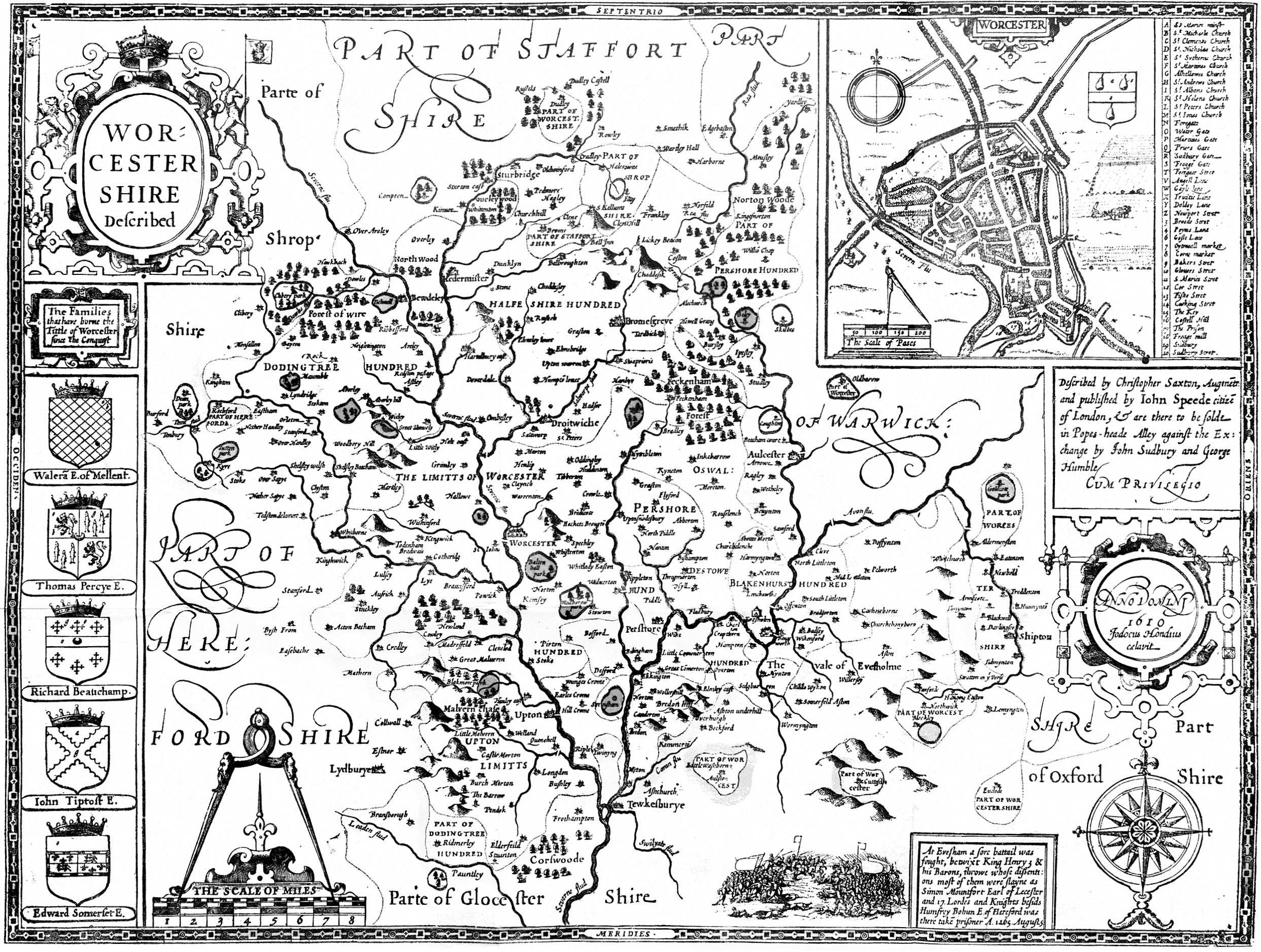
1610 Worcestershire, John Speed Image size: 2485x1877px (2573KB)
Monochrome image showing the whole of Worcestershire, including Stourbridge and Oldswinford in the north. |
 |
|||||||||||||||||
|
Download PDF (2304KB)
|
||||||||||||||||||
|
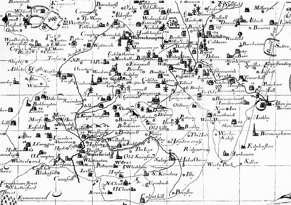
1695 N Worcs and S Staffs, Robert Mordern Image size: 1200x848px (736KB)
Monochrome image showing the whole of parts of Worcestershire and Staffordshire around Stourbridge and Oldswinford. |
 |
|||||||||||||||||
|
Download PDF (682KB)
|
||||||||||||||||||
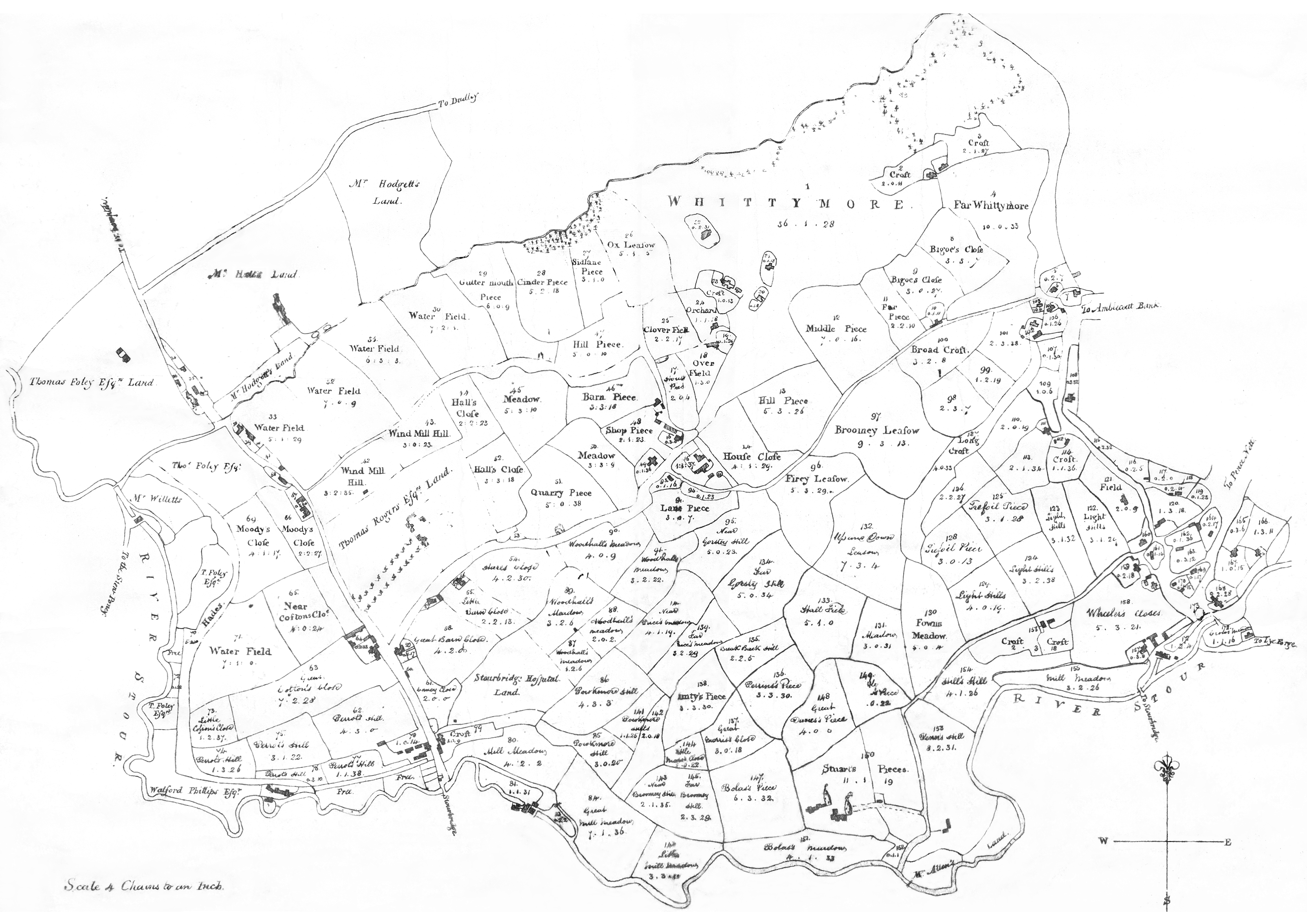
|
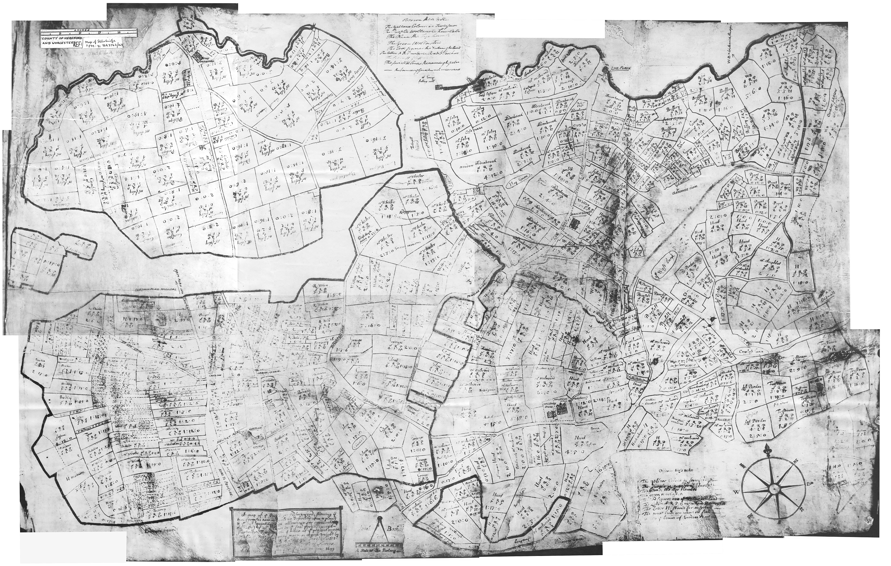
1699 Oldswinford Parish, Josiah Bach Image size: 3102x1970px (5323KB)
Monochrome image of photocopies of Bach's plan. I believe these copies once belonged to the late H Jack Haden, the well known Stourbridge historian and author. This composite image shows the various parts of the parish as they appeared on Bach's original. Most of the field owners' names and field acreages are just legible. There are also some modern annotations. |
 |
|||||||||||||||||
|
Download PDF (4566KB)
|
||||||||||||||||||
|
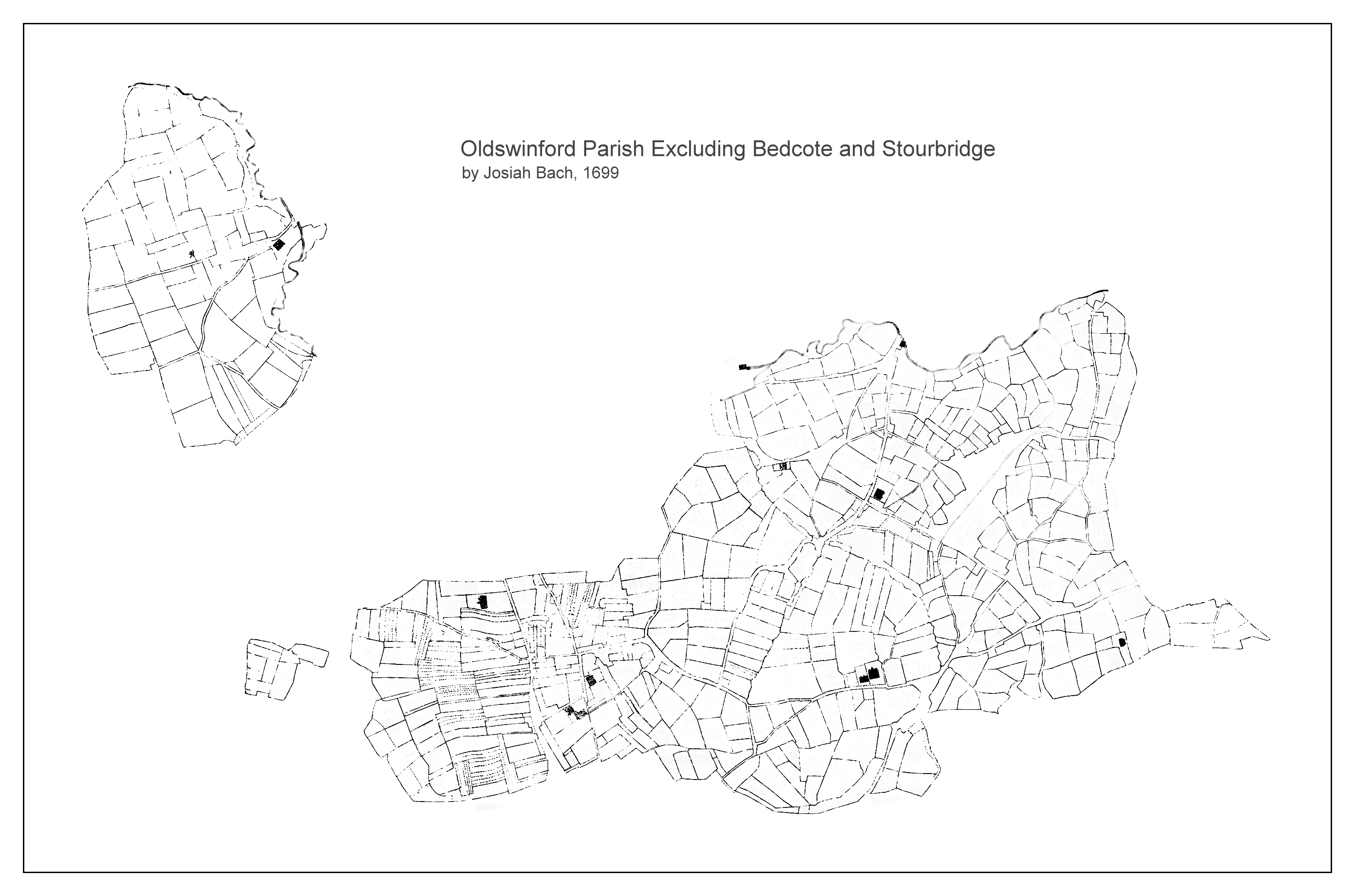
1699 Oldswinford Parish, Josiah Bach Image size: 2954x1954px (368KB)
Monochrome image of Bach's plan with the various segments (Wollaston, fields near Gig Mill, and Foxcote) assembled and shown in roughly the correct location. This is a digitally cleaned version with field owners and acreages removed. See above for a version of Bach's plan with all details present. |
 |
|||||||||||||||||
|
Download PDF (364KB)
|
||||||||||||||||||
|
Image size: 3327x2353px (2529KB)
Monochrome image of Amblecote. This is a digitally cleaned copy of a photocopy. The original is held in Enville Hall archives. |
 |
|||||||||||||||||
|
Download PDF (2495KB)
|
||||||||||||||||||
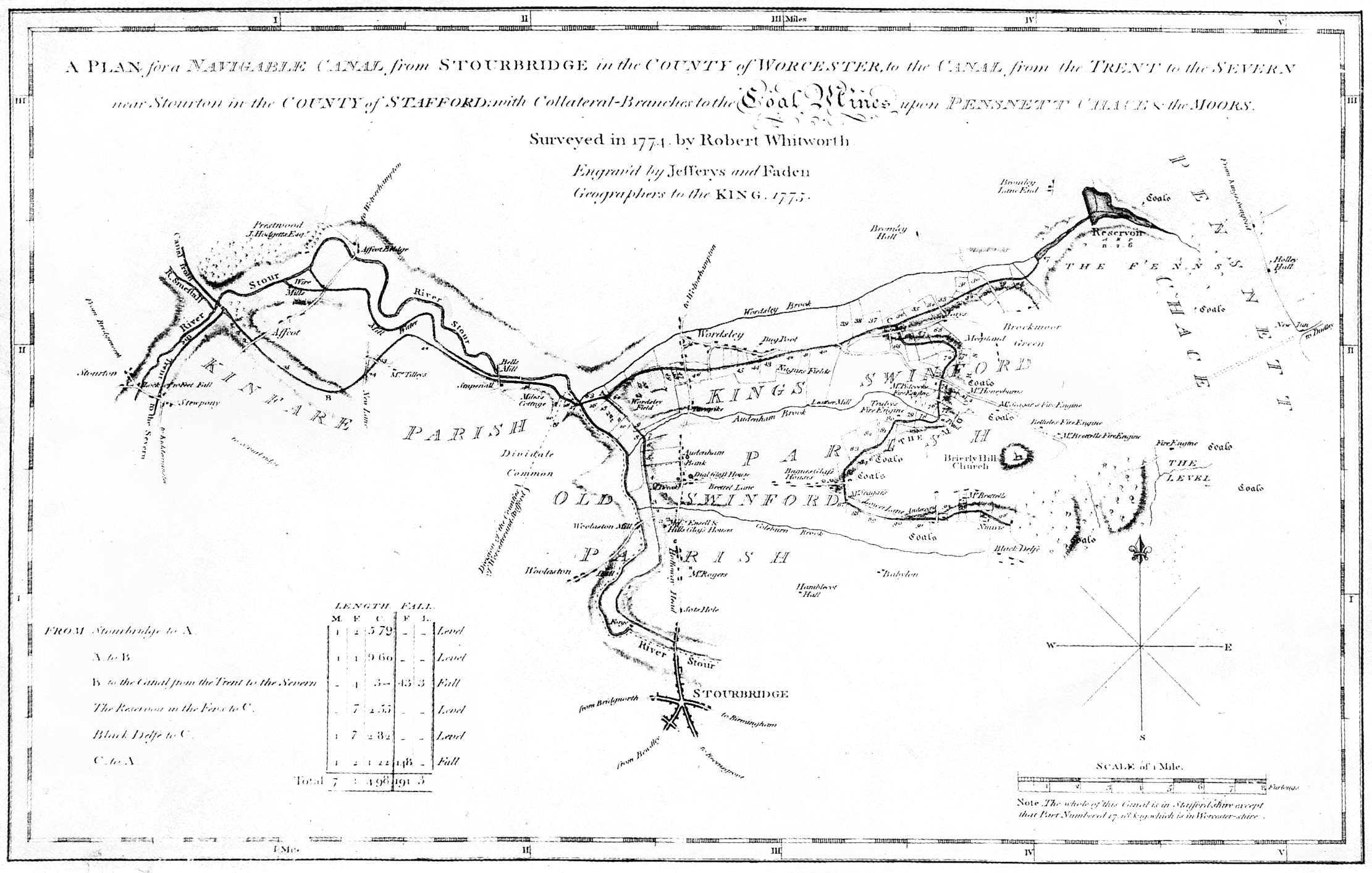
|
1774 Stourbridge Canal, Robert Whitworth Image size: 2221x1414px (1341KB)
Monochrome image showing the area around Stourton, Prestwood, Wordsley, Stourbridge, Amblecote and Brierley Hill. |
 |
|||||||||||||||||
|
Download PDF (1328KB)
|
||||||||||||||||||
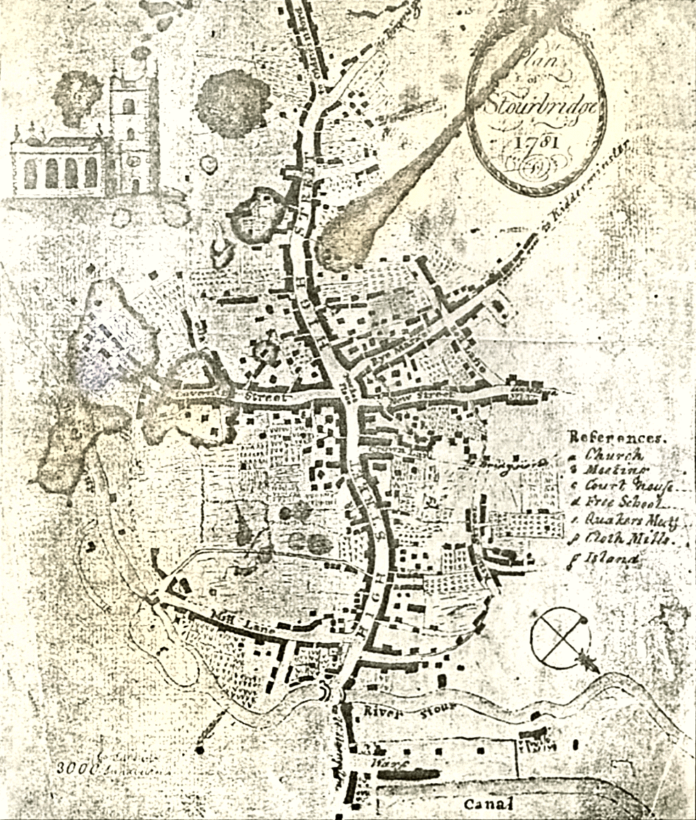
|
Image size: 982x1157px (845KB)
Probably the earliest plan of the town centre. Note that it is drawn in an unusual orientation (with South West at the top). There appear to be some significant distortions in the layout. |
 |
|||||||||||||||||
|
Download PDF (756KB)
|
||||||||||||||||||
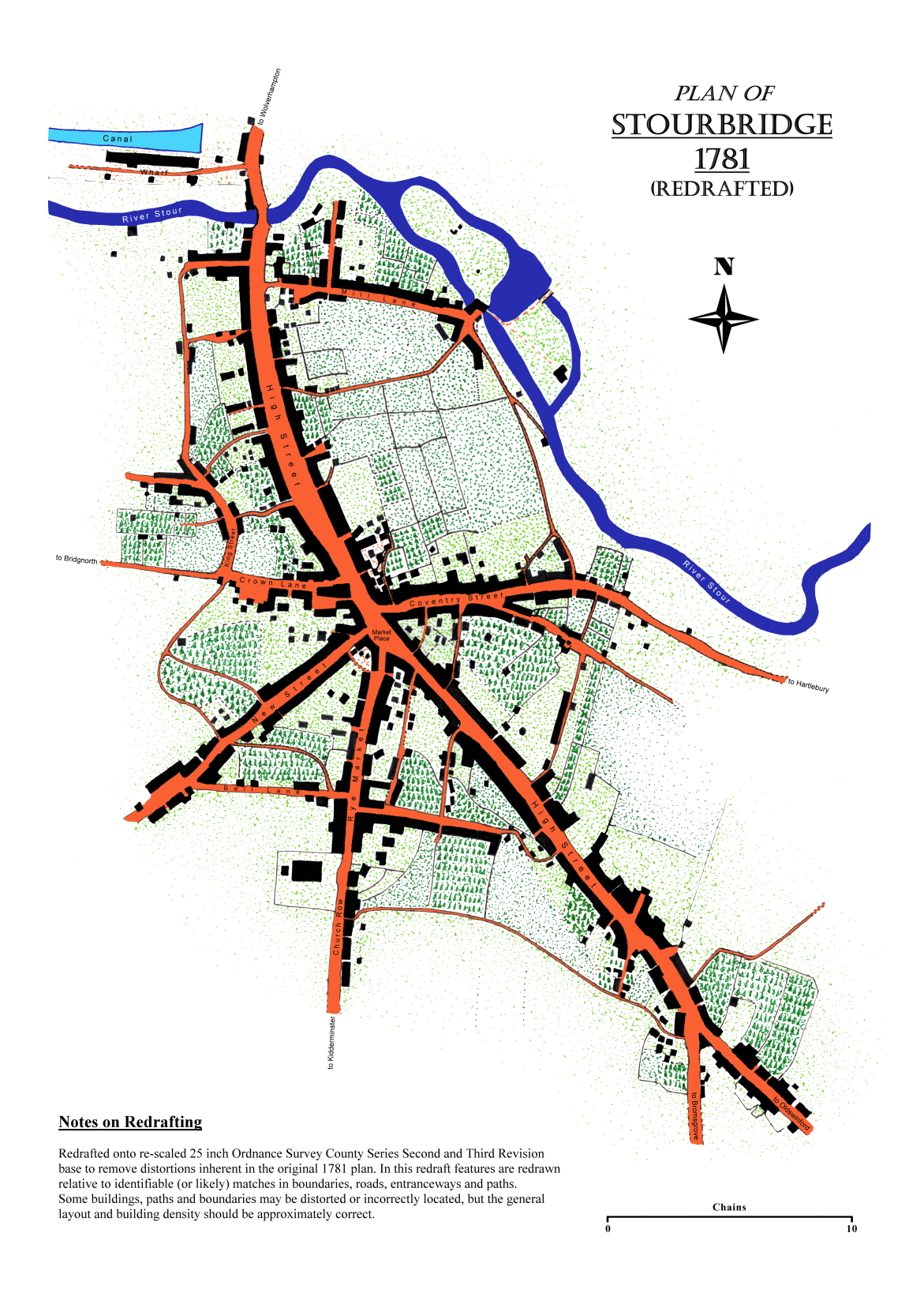
|
1781 Stourbridge Town (Modern Redraft) Image size: 1171x1657px (359KB)
Modern colour redrafting of the 1781 town plan (above). This has been redrawn from the original using the 1882 OS survey 25-inch maps as a base. |
 |
|||||||||||||||||
|
Download PDF (351KB)
|
||||||||||||||||||
|
1782 Oldswinford, Court & Blackden Image size: 8223x5817px (12665KB)
Monochrome image assembled from photocopies, showing the whole of Oldswinford parish except Amblecote. The original was compiled as part of the Enclosures survey. Land owners are shown. In most cases the text is legible on this copy, but for for some of the smaller writing you might need to visit Worcestershire Record Office. (Stourbridge Public Library holds a photocopy, but this is not of great quality and decaying sellotape obscures some of the details.)
|
 |
|||||||||||||||||
|
Download PDF (11533KB)
|
||||||||||||||||||
|
1787 Worcestershire, John Cary Image size: 1227x1537px (752KB)
Colour image showing the whole of Worcestershire, including Stourbridge and Oldswinford in the north. Note the black line running from Worcester, via Bromsgrove, to Stourbridge. This is the route of the proposed Worcester-Stourbridge canal, which would have run close to the Withybrook through Norton (near Lea Vale Road, through Mary Stevens Park and along Fredericks Close), then past Gig Mill, and alongside Mamble Road and Lowndes Road, joining the Town Arm of the Stourbridge canal near Canal Street. However, it was never built due to local opposition. Instead, a revised route took it direct to Birmingham, and it thus became the Worcester-Birmingham canal. |
 |
|||||||||||||||||
|
Download PDF (699KB)
|
||||||||||||||||||
|
1827 Oldswinford Parish, Brettel & Davies Image size: 3274x2184px (575KB)
Monochrome image of the 1827 plan. The original consisted of five separate plans: this is a digitally cleaned composite of all five without field index numbers.
|
 |
|||||||||||||||||
|
Download PDF (561KB)
|
||||||||||||||||||
|
1837 Stourbridge Town Plan, John Wood Image size: 2289x3003px (3788KB)
Monochrome image showing Stourbridge town centre and the area south of the town, down to the Heath Pool (now in Mary Stevens Park). |
 |
|||||||||||||||||
|
Download PDF (3393KB)
|
||||||||||||||||||
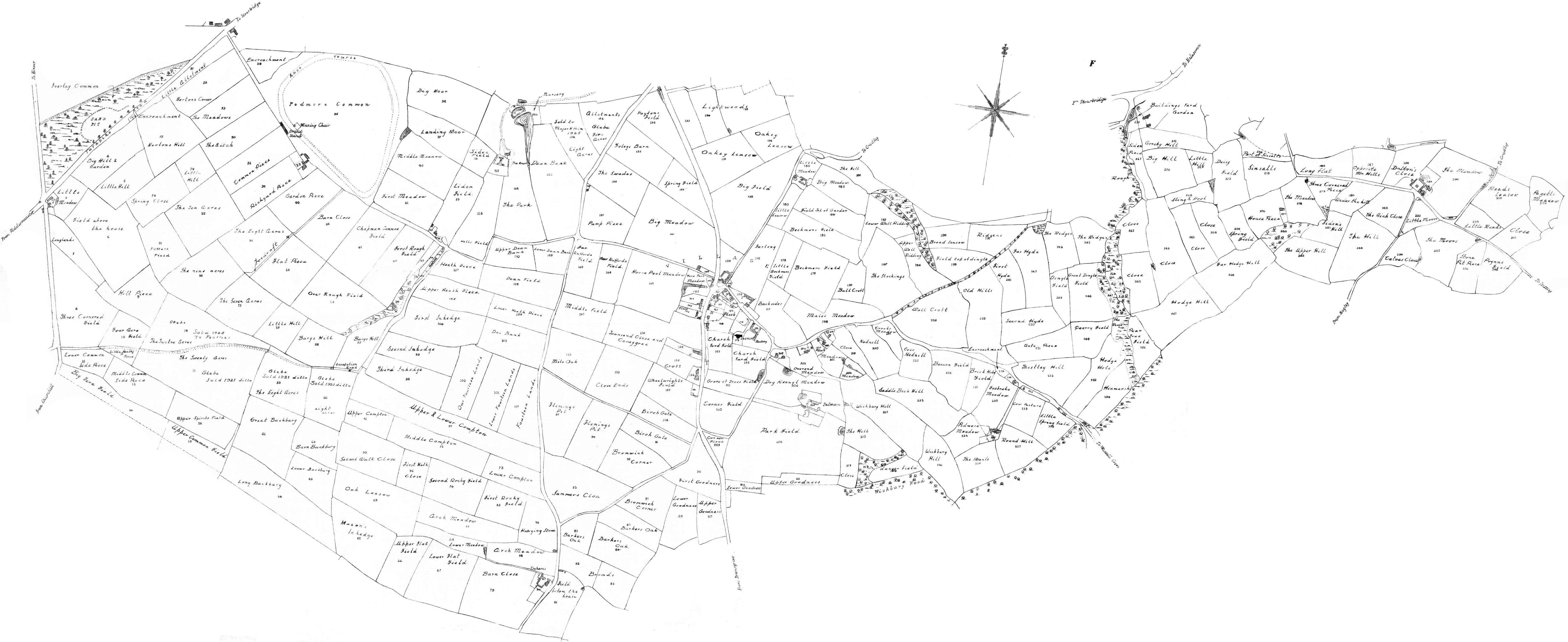
|
Image size: 5489x2247px (1856KB)
Monochrome image showing the parish of Pedmore. Landowners are shown. |
 |
|||||||||||||||||
|
Download PDF (1839KB)
|
||||||||||||||||||
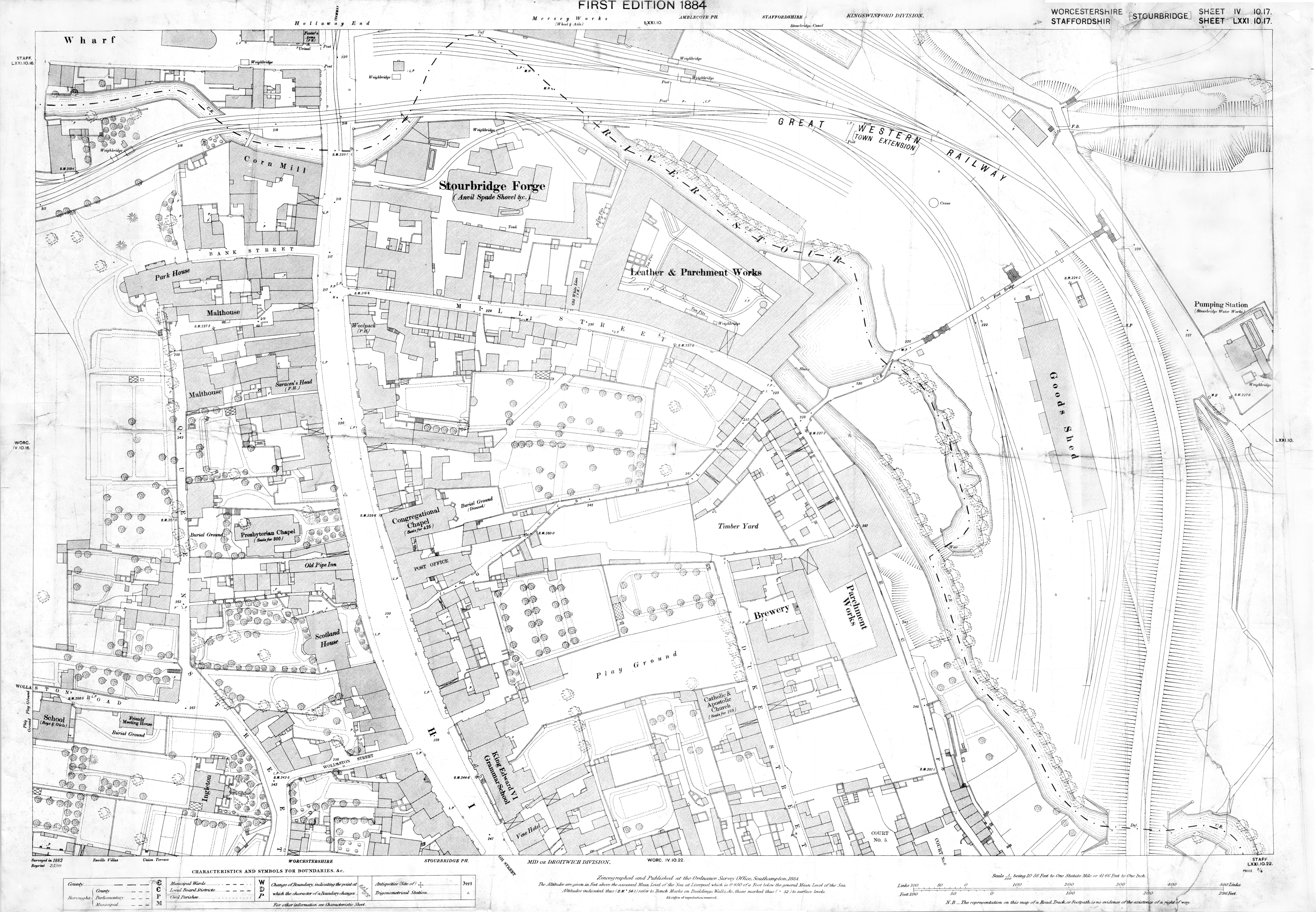
|
1884 Stourbridge Town (N) 1:500, OS Image size: 6050x4192px (13239KB)
Copy of Ordnance Survey 1:500 scale County Series first edition sheet 4.10.17 showing the north part of Stourbridge town centre including Lower High Street, Mill Street, Wollaston Street, Queen Street and The Cliff.
|
 |
|||||||||||||||||
|
Download PDF (11698KB)
|
||||||||||||||||||
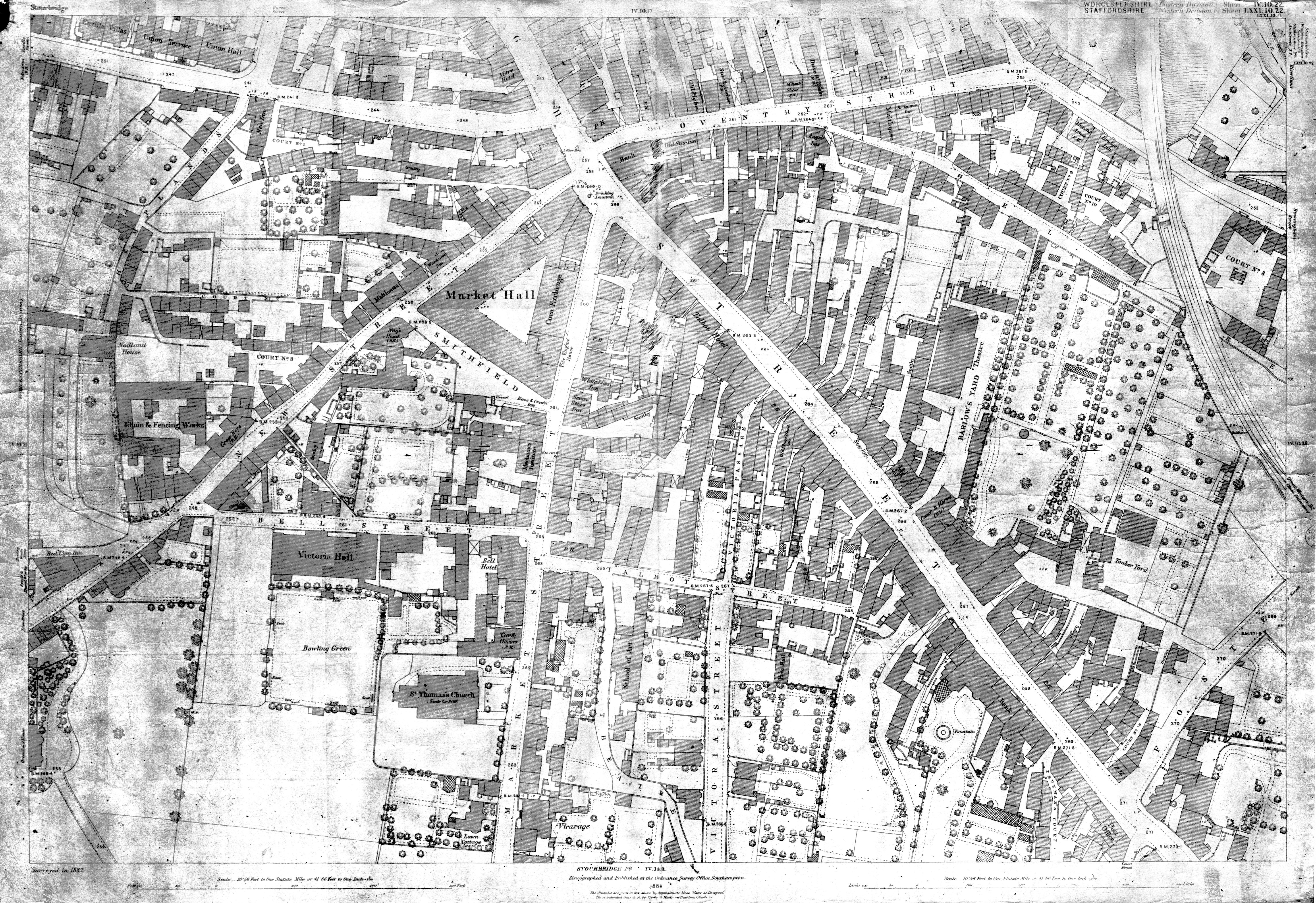
|
1884 Stourbridge Town (S) 1:500, OS Image size: 5946x4082px (20660KB)
Copy of Ordnance Survey 1:500 scale County Series first edition sheet 4.10.22 showing the south part of Stourbridge town centre including Crown Lane, New Street, High Street, Market Street, Bell Street, Victoria Street. Foster Street and the N end of Court Passage.
|
 |
|||||||||||||||||
|
Download PDF (17599KB)
|
||||||||||||||||||
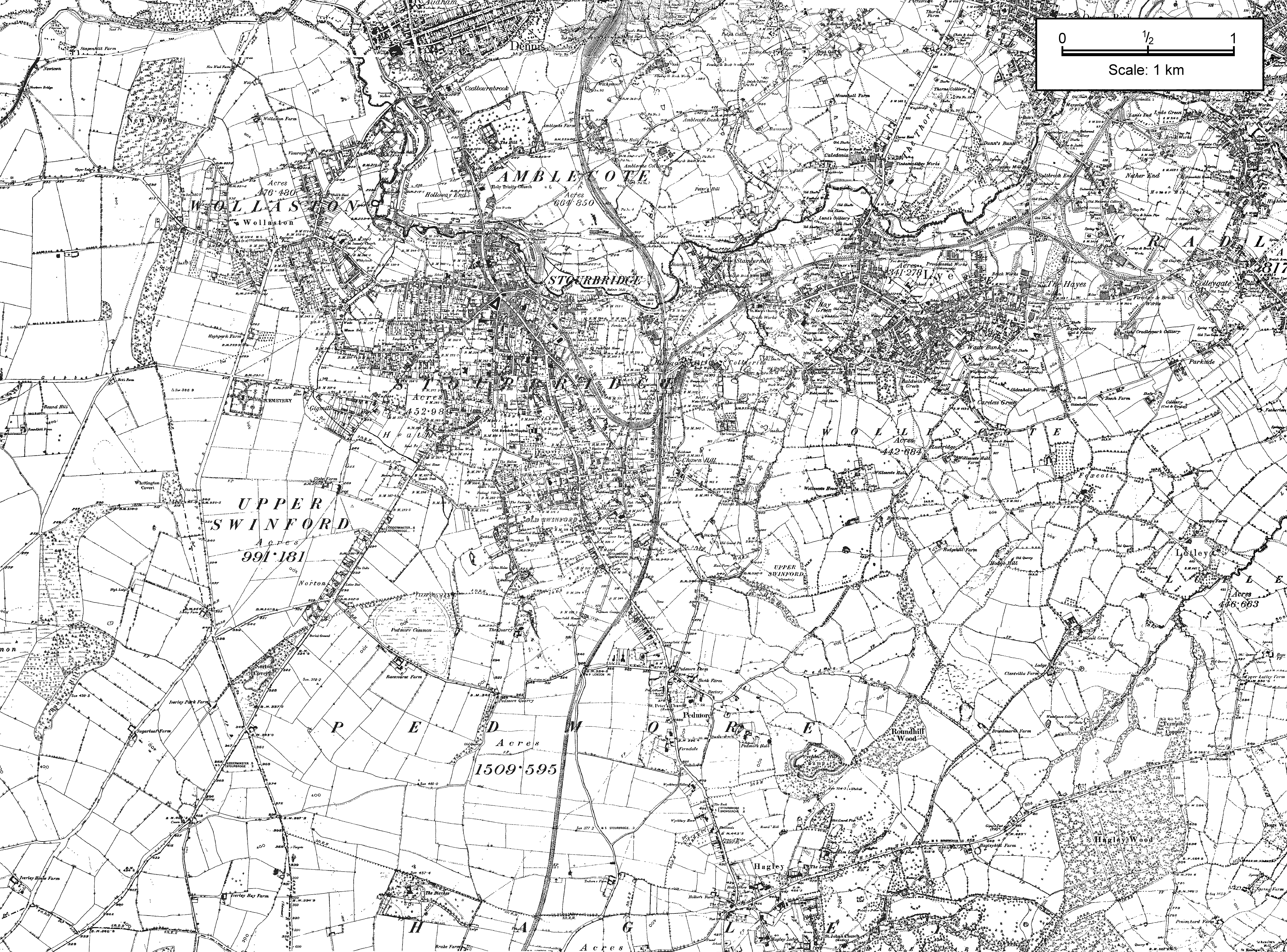
|
1888 Oldswinford and Pedmore Parishes, OS Image size: 4240x3136px (3918KB)
Composite of Ordnance Survey County Series 6-inch first edition sheets showing the area around Stourbridge, including (most of) Amblecote, Lye, Wollescote, Foxcote, Upper Swinford, Norton, Pedmore, Wychbury Hill and part of Hagley.
This is a large image, and the GIF version might not display on some browsers. If you experience difficulties, try viewing the PDF version instead. |
 |
|||||||||||||||||
|
Download PDF (3730KB)
|
||||||||||||||||||
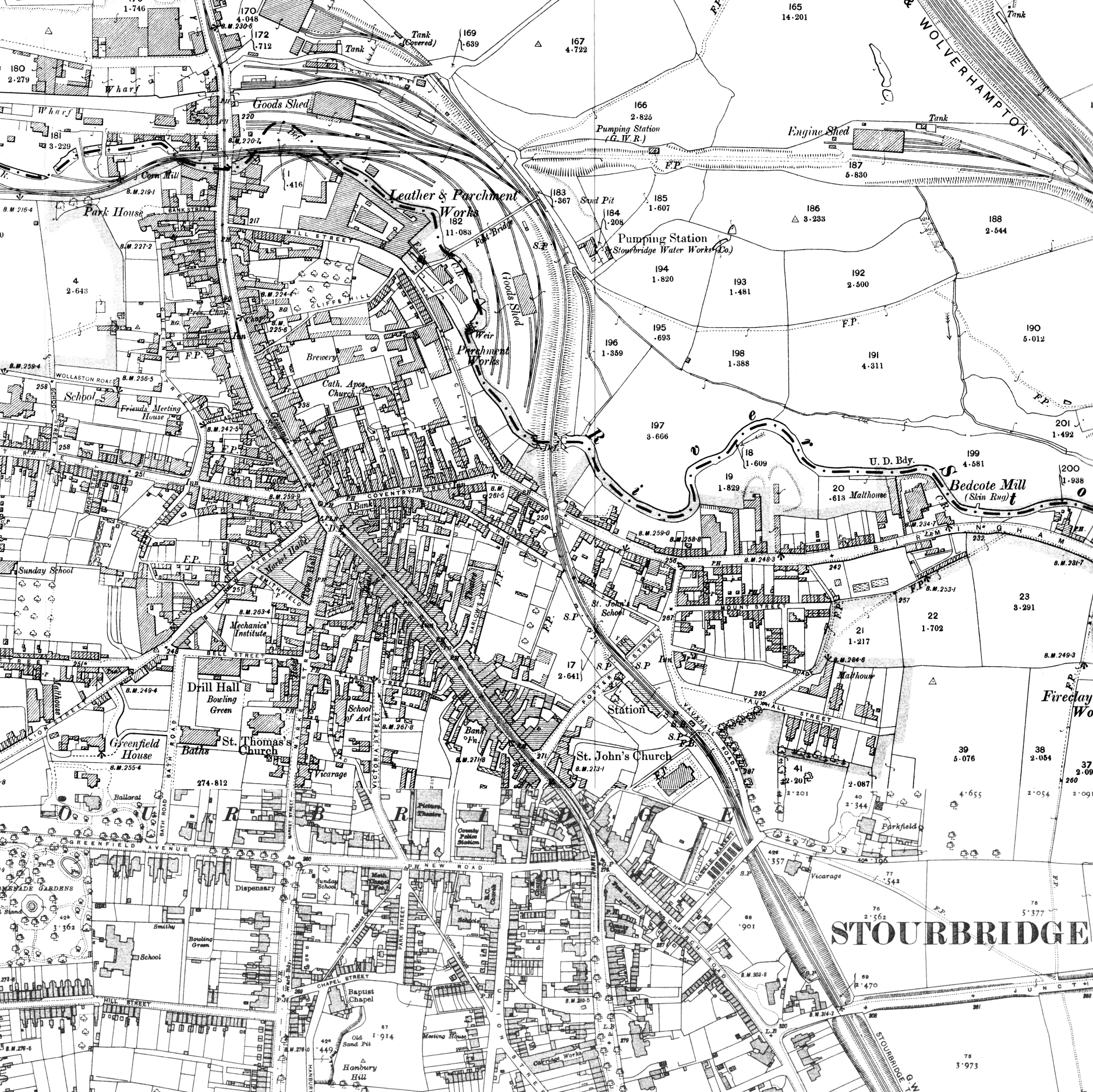
|
1903-1914 Stourbridge Town, OS Image size: 1877x1875px (1874KB)
Composite of Ordnance Survey County Series 25 inch first and second revision sheets showing Stourbridge town centre. If you are interested in 25-inch OS maps of the wider area, a good range of reduced-size reproductions is available from Alan Godfrey Maps for just a few pounds each. These cover most of the area around Stourbridge: Wordsley down to Pedmore, and Norton across to Lye and Wollescote. |
 |
|||||||||||||||||
|
Download PDF (1554KB)
|
||||||||||||||||||
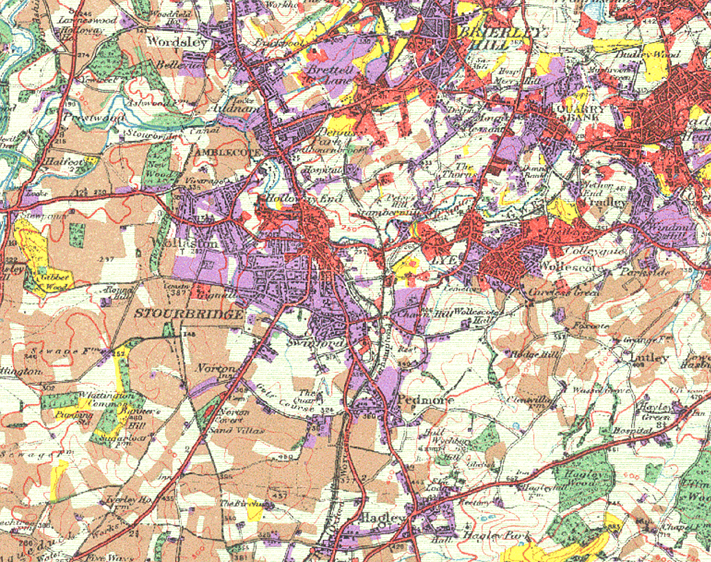
|
Image size: 1033x816px (708KB)
Surveyed at 1:10,560 and published at 1:63,360 scale, Sir L Dudley Stamp's National Land Utilisation Survey indicates six classifications of land use in the 1930s (the exact date of this map's publication is unknown). Sorry, no key is available at present, but the meaning of most of the colours should be fairly obvious to anyone familiar with the area. |
 |
|||||||||||||||||
|
Download PDF (633KB)
|
||||||||||||||||||
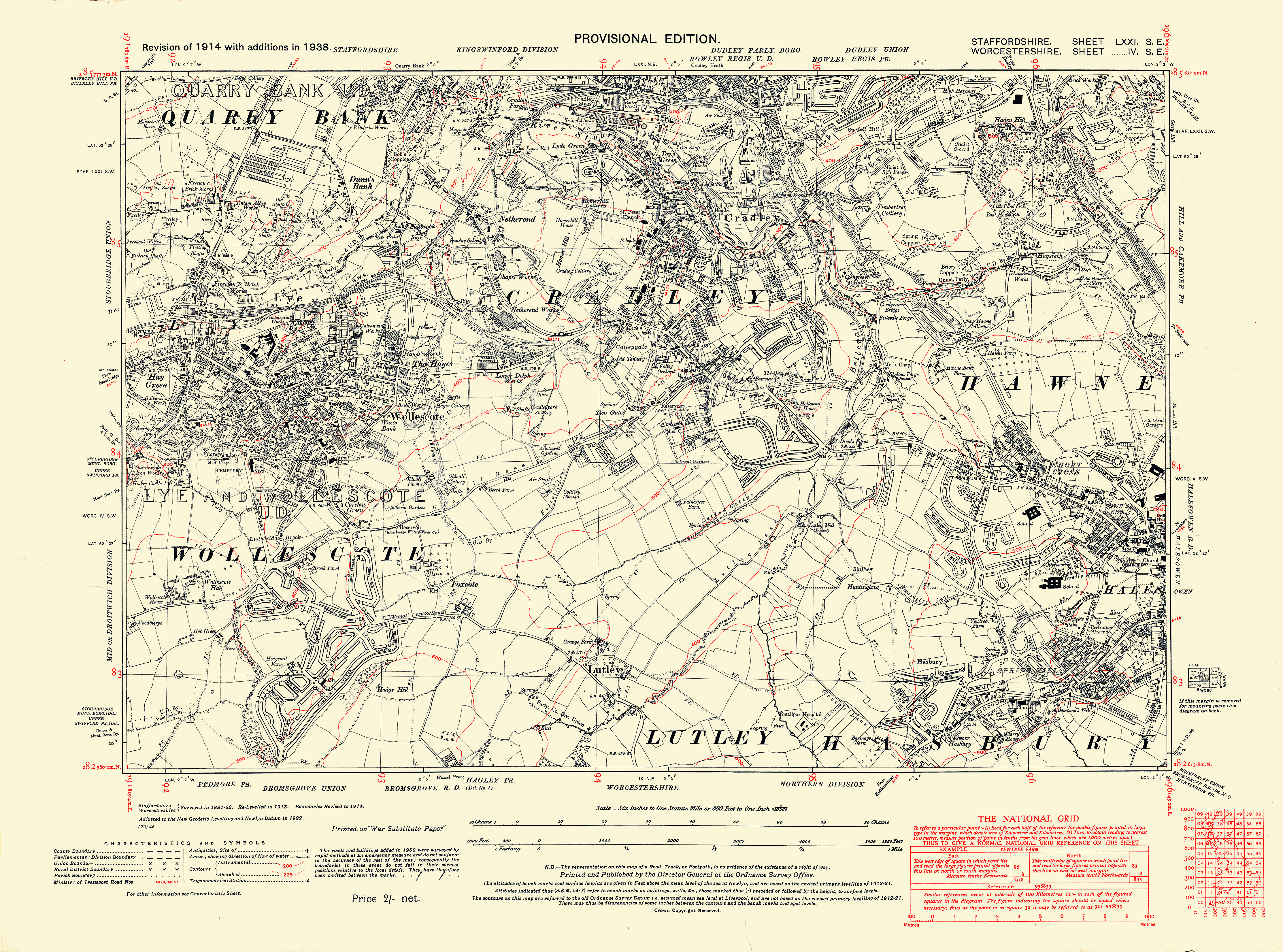
|
1938 Lye, Wollescote, Foxcote, OS Image size: 4452x3303px (2734KB)
OS County Series 6-inch Provisional Edition sheet IV SE, based on the 1914 revision with additions in 1938.
|
 |
|||||||||||||||||
|
Download PDF (2683KB)
|
||||||||||||||||||
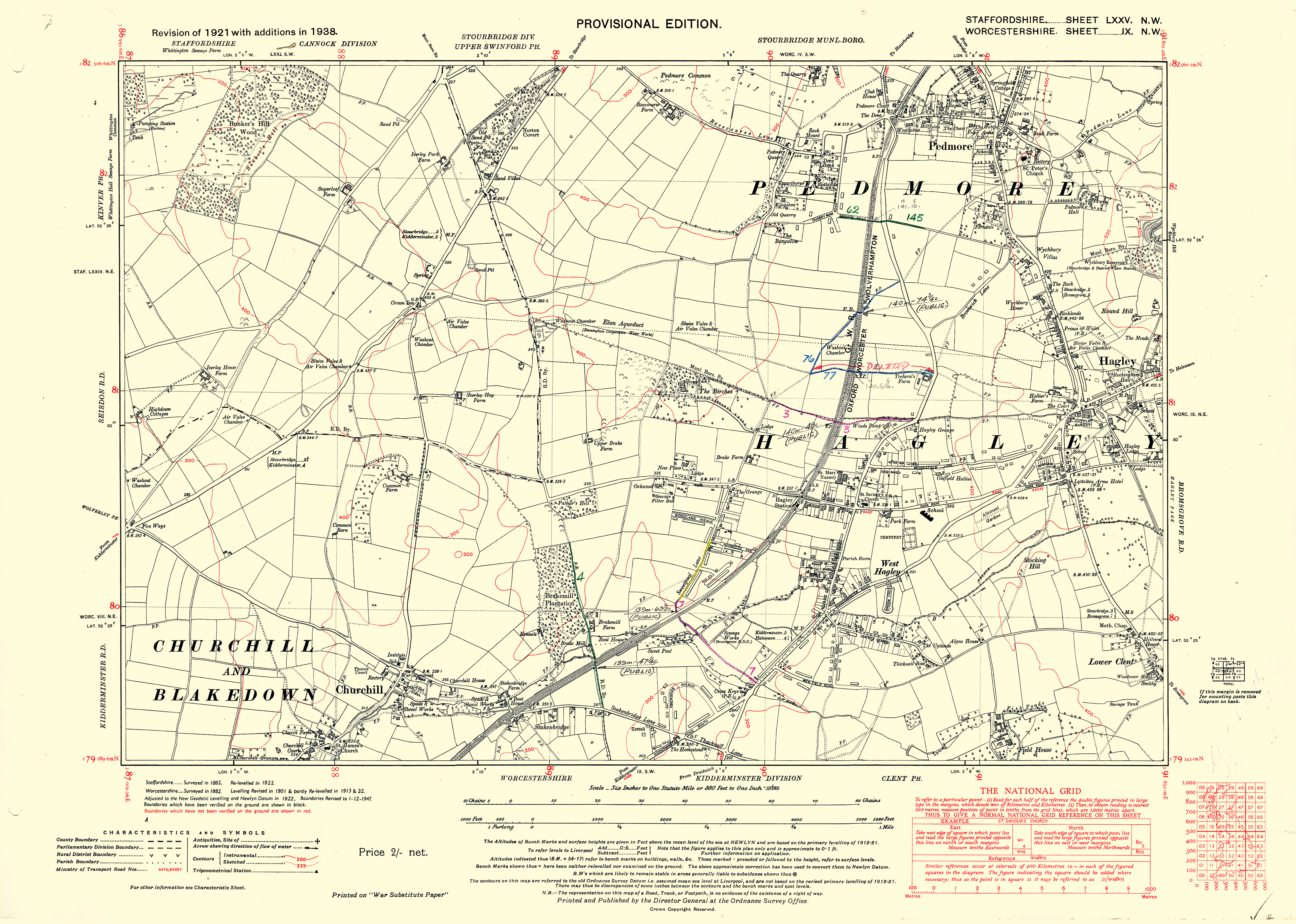
|
1938 S Norton, Churchill, Pedmore, OS Image size: 4497x3207px (1719KB)
OS County Series 6-inch Provisional Edition sheet IX NW, based on the 1921 revision with additions in 1938. This map includes some later ink and wash annotations relating to the railway.
|
 |
|||||||||||||||||
|
Download PDF (1745KB)
|
||||||||||||||||||
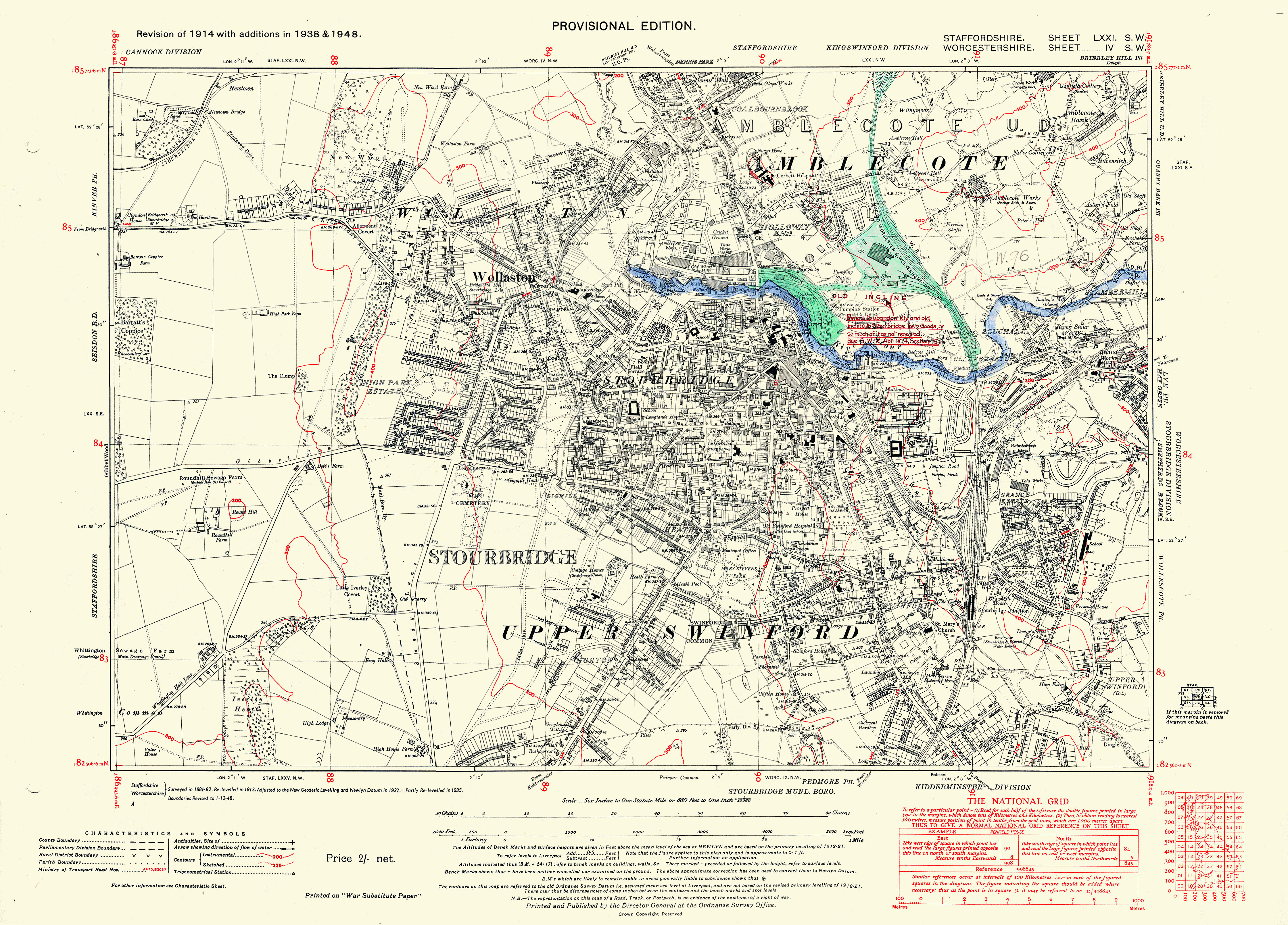
|
1948 Stourbridge, Amblecote, Norton, OS Image size: 4481x3219px (3166KB)
OS County Series 6-inch Provisional Edition sheet IV SW, based on the 1914 revision with additions in 1938 and 1948. This map includes some later ink and wash annotations relating to the railway.
|
 |
|||||||||||||||||
|
Download PDF (2982KB)
|
||||||||||||||||||
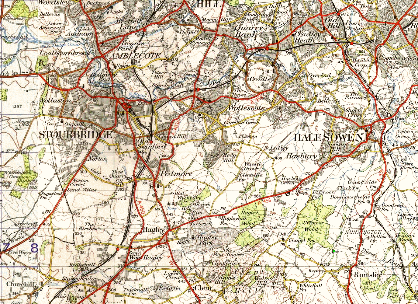
|
Image size: 1379x999px (936KB)
OS New Popular Edition 1-inch map, showing Stourbridge, Amblecote, Pedmore, Hagley and Halesowen. |
 |
|||||||||||||||||
|
Download PDF (1078KB)
|
||||||||||||||||||
|
Notes and Bibliography
Ordnance Survey Map Scales and Editions Old OS maps were published at a variety of scales. The most common of these are:
Old Series Maps Map sheets covering the Stourbridge area were published between 1831 and 1835.
County Series Maps - First Edition Sheets covering the Stourbridge area surveyed in 1882 and published in 1888.
County Series Maps - First Revision Sheets covering the Stourbridge area were published in 1901-4.
County Series Maps - Second Revision Sheets covering the Stourbridge area were published in 1913-4 and 1921.
County Series Maps - Third Revision Sheets covering the Stourbridge area were published in 1937-8.
National Grid Series Maps - Provisional Editions Some of the Third Revision County Series sheets were republished with additions in 1948-54 on the new National Grid lines. The "additions" did not amount to a complete "1:2500" survey, so some new features of the landscape (e.g. field boundaries and ponds) are not shown. Any new buildings amongst the 1948-54 additions are shown unfilled (Churchill Drive in Amblecote, for example) whereas older (pre-third-revision) buildings are shown hatched.
Popular Edition Complied at "1-inch" scale, the Stourbridge area maps were published circa 1920.
New Popular Edition A revised version of the Popular Edition maps published circa 1940-50.
Sources of Reproduction Maps and Images
Reproductions of one-inch Old Series (1834), six-inch and possibly 25-inch County Series (late 19th, early 20th century), Popular Edition (1920s) and New Popular Edition (1940s) OS maps etc. Downloadable and printed products.
Alan Godfrey Maps: The Godfrey Edition First class and economically priced printed reproductions of mainly 25-inch OS maps from the first and second revisions of the OS County Series (early 20th century). The maps are slightly reduced in size (from 25-inches to the mile to about 17-inches to the mile), but all details are perfectly legible. Coverage includes most of the Stourbridge, Pedmore, Lye, Wollescote, Wordsley, Cradley and Brierley Hill areas.
British Library Online Gallery - OS Surveyors' Drawings Visitors to this web site can view the British Library's collection of 351 Ordnance Survey surveyors' drawings that covers most parts of England south of Liverpool. The drawings were made in the late eighteenth and early nineteenth centuries as part of the preparatory work for the OS 1-inch 'Old Series' maps. The surveyor's drawings were compiled at a somewhat larger scale (2 inches to the mile or larger) and show many features that did not appear on the subsequent published maps. Be aware however, that a number of field boundaries depicted on the drawings differ from those recorded on the later 6-inch OS maps as well as on earlier enclosure plans. In places the distinctive boundary pattern left by medieval open-field agriculture, which is very clear on the 6-inch OS maps of the 1880s, is somewhat obscured on the OS surveyors' drawings.
Publications on Local History Below is a short list of useful publications, together with links to the relevant product pages of Amazon.co.uk. In some cases the books are available more cheaply from other sources, such as the Black Country Society or the publishers themselves.
Articles A few of my articles (including maps and plans) on various aspects of the historic Stourbridge landscape are also available to download. Just click on the appropriate link below.
The Swinford Charter (s579) of AD951-9 Stourbridge town developed within the ancient parish of Oldswinford; and the Swinford Charter affords a unique insight into the origins of these land units. Historians have been unable to decipher parts of the charter's boundary clause. Can you identify any of its Anglo-Saxon boundary landmarks?
Stourbridge's Western Boundary Stourbridge's western boundary may be over 2000 years old. It seems to have begun as a tribal frontier and over the centuries it has delineated medieval manors, the Worcester diocese, ancient parishes, the domesday hundred of Clent and Kinver Forest. It may also have marked the north-west limits of the Anglo-Saxon kingdom of the Hwicce.
The Kowback: Stourbridge's Misplaced Brook It's not the Clatterbatch. It's not the Swin Brook. It's not where Google Maps says it is. Clues to this brook's true locality and the origin of its name lie in two seventeenth-century documents.
The Place Names of Stourbridge, the Black Country and their Environs This article discusses the origin and interpretation of some of the commonest place-name elements and presents almost three hundred examples from the vicinity of the Black Country. Several place names around Stourbridge are examined in more depth. Brook Holloway; The Ham House and Ham Lane; Hungary Hill; Wynall Lane; Catherwell (Meadow, House, Terrace, Field and Saw Mill); Hanbury (Yearnebarrowe) Hill, Pepper Hill, and local stream names are discussed together with other topics of regional importance such as the Hwiccan kingdom; Kinver Forest; the Ismere Diploma; the province of the Husmeræ; the Swinford charter, and the origin of Pedmore.
|
||||||||||||||||||
 The
Black Country as Seen Through Antique Maps by Eric Richardson
The
Black Country as Seen Through Antique Maps by Eric Richardson A
History of Stourbridge by Nigel Perry
A
History of Stourbridge by Nigel Perry A
History of Wollaston by The History of Wollaston Group
A
History of Wollaston by The History of Wollaston Group Street
Names of Stourbridge and its Vicinity - Volume I by H Jack Haden
Street
Names of Stourbridge and its Vicinity - Volume I by H Jack Haden A
Brief History of Lye and Wollescote by Don Cochrane
A
Brief History of Lye and Wollescote by Don Cochrane The
Stourbridge Canal by J Ian Langford BSc(Eng), PhD, DSc, MIEE
The
Stourbridge Canal by J Ian Langford BSc(Eng), PhD, DSc, MIEE Maps
for Historians by Paul Hindle
Maps
for Historians by Paul Hindle
*Notification of copyright infringement
If you believe that copyright still exists on any of the images on this web page, please notify me, K James, by email at kjames_sd@hotmail.com giving full details so that I can take appropriate remedial action.